Thursday, December 4, 2014

December 8, 2014 Paint-Out at Tahoe Meadows

Tahoe Meadows Mt. Rose Hwy facing East - this was taken last year in the fall
We have fresh snow on the mountains.  If you are into snow - please join us!  Hopefully the winds will be calm.  Forecast so far says no precip on this day.

Date:        December 8, 2014 (Monday)
Time:          10:00 am
Place:          Tahoe Meadows at the top of Mt. Rose Hwy 431
Amenities:      none - I think the restroom at the trail head might be closed, as is the access drive to it
Parking:          on the highway
Where to meet:    the south side of the highway where the stairs are and the trails

What to bring:
  • snow boots (maybe snowshoes?  x-country skis?)
  • warm clothes, gloves, hats, ear covers?
  • sunglasses, hat
  • camera
  • art gear that is portable 
  • Food and drink
  • cell phone
  • possibly art umbrella
Might be this much snow - this was last winter

Directions:  if you are new to the area:
From Reno or Carson City:  Take 395/580 to the Mt. Rose Hwy (431), go up to the summit and as you continue downhill you will see a large meadow before you.  At the level area, park on either the right or left hand side of the hwy on the shoulder.  We will be meeting on the south side (your left), but you can explore either side of the hwy and paint.
From Incline Village:  Go up Mt. Rose Hwy (431) towards Reno.  Before you get to the summit, park on the shoulder at the level area of the meadow.  There are two sets of stairs to go down into the meadow on your right.

Saturday, November 29, 2014

No Paint-Out Dec. 1 - AND - How to Paint Water

Hello my painting friends,

These storm fronts moving in and the daily changing forecasts for Monday Dec. 1, 2014 make for a good day to paint in the studio.

Last week a painter and I discussed the challenge of painting water.  I remembered reading a blog post about this subject by a fine California artist Terry Miura.  I invite to you click on this link to read his informative post:

http://terrymiura.blogspot.com/2014/10/transparent-water.html

This post was so informative that I printed it out for myself for reminders.  He has other helpful posts.  You may want to subscribe or follow his blog.

Happy painting!  Hopefully the next week we will have fair weather and can paint the great outdoors!

Carolyn

Wednesday, November 19, 2014

November 24, 2014 Paint-Out near Wedge Parkway


Since there is a storm predicted on Saturday, if we get a dusting of snow on Mt. Rose and Slide Mt. and the sun comes out, here is a place where the view of these mountains is very good.  This is an old ranch property that is open to dog walkers, people who fly remote controlled planes, etc.  There are some old cottonwood trees with character too.  Plenty of parking and you can drive around as well.  This area is right across the street from South Meadows Library - the big mustard-colored building.  Also close is Starbucks, Raleys, and McDonalds at the intersection of Wedge Parkway and Mt. Rose Hwy.

Date:          November 24, 2014 (Monday)
Time:         9:30 to 10:00 - depending on how cold the morning is
Place:         The old ranch - open lot - at the corner of Wedge Parkway and Whites Creek Lane
Amenities:   The library is across the street, Starbucks, Raleys and McDonalds down the street

Note:  I don't think we will get so much precip that it would be muddy, but if it is, you can park across the street at the library.  Signs on Whites Creek Lane say no parking.

There are some homes and power poles in some of your views, but that is what is so great about being an artist --- we can eliminate those!

You can also see Peavine and the Virginia foothills from here.  It is just a nice wide-open area.

DIRECTIONS:  From I-80 and 580 intersect:

  • South on 580
  • Exit 59 - Damonte Ranch Parkway
  • Turn Right on Damonte Ranch Pkwy, it turns into Arrowcreek about where the intersection of Virgina Street is
  • Continue on Arrowcreek Parkway - stay left 
  • at about .8 miles turn left on Wedge Parkway
  • First right turn at about .3 miles on Whites Creek Lane
  • Immediate right into dirt parking area in the old ranch

PS: HAPPY THANKSGIVING!

Wednesday, November 12, 2014

November 17, 2014 Let's Paint Dunes! Washoe Lake Paint-out

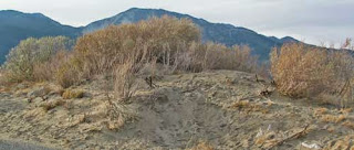
All this pictures were taken at 3:00 in the afternoon and it was overcast

Have you painted the dunes with iceplant along the Monterey coast?  Well, if you miss that, you must try painting our own Nevada dunes with sagebrush and rabbit brush and other native plant life growing on it!

Date:          November 17, 2014
Time:          9:30 am
Place:          Washoe Lake State Park - the North Boat Ramp Entrance
Meet:           In the above-mentioned parking lot
Amenities:    Bathrooms, picnic tables, dog-friendly
Fee:              $5.00 Nevada residents, $7.00 out of state - per car
Fees required year round

Washoe Lake may be dried up quite a bit, but it is still a nice area to paint.  This particular entrance has dunes close to the parking lot.  There are also sandy beach areas with grasses here and there.  There is also a wonderful view of Slide Mountain in the background.  So there is lots to choose from and your dog will love it.  It is off season so there is no one there - hardly.


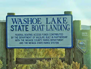
The sign at the entrance off of Lakeshore Drive

Endless beaches since the lake is so dried up
Directions:
From Reno Downtown 80/395/580:  Take 580 south, Exit 47B for old 395 South/Virginia Street.  Continue on old 395 going south (Virginia Street) (don't go to Virginia City)about 6.8 miles.  At the top of a hill, get in the left-turning lane.  Turn Left on East Lake Boulevard.  Go about 2.1 miles and turn right on Lakeshore Drive.  If you miss this turn, just turn at any other street and it will take you the same road - Lakeshore Drive - which follows the edge of the lake.  Continue about 1.8 miles until you see the sign (pictured above) and turn right.  Go to the end and meet in the parking lot.

Links:  http://parks.nv.gov/parks/washoe-lake-state-park/

Monday, November 3, 2014

November 10, 2014 Silver Saddle Ranch, Carson City Paint-Out


Date:          November 10, 2014
Time:          10:00 am
Place:          Silver Saddle Ranch, Carson City, NV
Parking:       Parking area .6 miles down their gravel ranch road see above
Amenities:    bathroom, hiking trails, bird watching, picnic area, working cattle ranch, barns and caretaker house, hiking and horseriding trails
Meeting Place:   the parking area.  Painting areas in walking distance.

Directions:    
From Reno, take 580 south
Take exit 38 for Fairview Drive, keep in left lane
Turn Left at the light onto Fairview Drive
At the round-about, take 1st exit onto East 5th Street
Turn Right on Carson River Road
Follow Carson River Road for 1.4 miles to the entrance at a bend in the road.
Picture above shows their sign on Carson River Road
Follow their gravel ranch road .6 miles to the parking area near the hay barn and ranch buildings.

Links, pictures and trail maps:  
Friends of Silver Saddle Ranch  http://fossr.org/

What to bring:
  • camera
  • painting gear
  • carts will work here - level ground
  • drinking water
  • hat, sunscreen, sunglasses, umbrella
  • lunch or snacks
  • folding chair if you wish
  • bug spray (where there are cattle....there are flies)
What you can paint:
  • cattle (maybe - they do move around)
  • ranch and pasture vistas
  • some sagebrush and cottonwood trees
  • nearby Carson River if you choose to drive down the road
  • Ranch buildings


Wednesday, October 29, 2014

November 3, 2014 Commons Beach, Tahoe City Paint-Out


Date:          November 3, 2014 (Monday)
Time:          9:30 or 10 am (it can be chilly at the lake in the AM!
Place:          Commons Beach, Tahoe City
Amenities:  lots to choose from - you are downtown Tahoe City

Yep, I changed the location again.  I think I'll just take the schedule down ... no more schedules until next Summer when the weather is predictable!  Actually, several of our artists will be picking up their paintings that were on exhibit at North Tahoe Arts, so that is the main reason why I changed to this location.

What to bring:  I think you all know that by now!  There is nothing noteworthy about this location that requires anything special....like a compass or bear spray!  (Just joking)

Directions:  use Google Maps for Tahoe City.  Also, check out these links, one has a map.

Links:  http://www.aboutlaketahoe.com/beaches/commons_beach.htm
http://www.tahoepublicbeaches.com/tahoe-city-commons-beach/


Tuesday, October 21, 2014

October 27, 2014 Paint-Out at Cave Rock State Park

I had to use the internet since I have never stopped here to take a picture!
Please note this is a change from the original schedule
Date:          October 27, 2014 (Monday)
Time:          9:30 am
Place:          Cave Rock State Park, Lake Tahoe
Amenities:   Bathrooms, picnic tables, beach, views of Cave Rock and neighboring homes with their own piers
Fee:            Parking Fees are about $10/car

Since we have been painting fall colors the last several paint-outs, we decided to change this paint-out to a lake view paint-out.

What to bring:
  • camera
  • cell phone
  • $10 if you don't have a NV park pass
  • painting gear
  • food/drink
  • artist umbrella
  • camera
  • layers - watch the forecast
Links:
This YouTube is long, but toward the end they show the beach and view looking south with the homes and piers and the pretty beach:


Location:  This boat launch and beach state park  is located on the south side of the Tunnel through Cave Rock.

Directions:  please see google maps and enter your starting point, and the destination as "Cave Rock, Glenbrook, Nevada".  This park is near Glenbrook, Nevada and north of Zephr Cove.

Wednesday, October 15, 2014

October 20, 2014 (Monday) Paint-Out Luther Pass Ranch/Hope Valley

Carson River near Sorensens

It is possible the aspen leaves have been blown off the trees ... so ... we will meet at Pickett's Junction  at the restroom parking area in Hope Valley and survey our options in that area.  Here is a brief description of the locations to paint in that area:

1. Luther Pass Ranch:  About a mile from Pickett's Junction on Hwy 89 on the right-hand side.  This is an old ranch and the gate is still open.  Sorry, I do not have a photo of this area.

2. The area across Hwy 89 from Luther Pass Ranch is also a possibility.  This is still part of Hope Valley.

3. Carson River access:  There are many places along 88 to pull off and hike to the river for a beautiful view of just the river, aspens, willows, or the river and a view of Hope Valley and surrounding mountain peaks.  See map.  The areas indicated are in red from Sorensens to the beginning Blue Lakes Road.

Date:          October 20, 2014 (Monday)
Time:          9:30 am
Meet:          at the Pickett Junction bathroom parking lot

What to bring:

  • camera
  • cell phone (however service is next to none)
  • art gear
  • art umbrella, hat, sunglasses
  • food and drink
Services:  Sorensen's gift shop has snacks and maps, the restaurant is also open
Bathrooms:  Pickett's Junction and near the junction of 88 and Blue Lakes Road - on Blue Lakes Road.
Gas Station:  Markleeville

Directions from Reno:  Take 395 (580) South to Minden, turn right on Highway 88.  Approximately 1 hour 15 min. to Pickett's Junction from central Reno.


Wednesday, October 8, 2014

October 13, 2014 (Monday) Paint-Out Changed to Tamarack Lake

Tamarack Lake in summer colors - I look forward to seeing them now

The aspens at higher elevations are peaking - so we changed this paint-out location to Tamarack Lake!

Date:          October 13, 2014 (Monday)
Time:          9:30 am (we will wait a little longer if they are stopping traffic)
Place:          Tamarack Lake
Meet at:       Meet at the summit of Mt. Rose Hwy at the parking lot for the Mt. Rose hiking trailhead.  Those of us who drove from Reno will have passed the paved pull-out parking area for Tamarack Lake (which is one mile east of the meeting place of the summit).  If it is clear, we will all head back to this area which will be on your right-hand side while traveling east.  
Parking:      Parking for Tamarack Lake is one mile east of the Mt. Rose Summit Parking lot.  It is a paved pull-out on the east side of the highway.  There is room for 15 or so cars.
Trail to Tamarack Lake:    We will walk across the highway to the west side.  There is a sign saying no motorized vehicles.  The trail is unmarked but it is there.
Trail:          About a 10 minute walk uphill.  Hiking shoes and backpacks are advised.  I would say it is "Moderate" in climb.

What to bring:

  • camera
  • painting gear
  • bug spray
  • sunscreen, hat, sunglasses
  • light layers
  • food/drink
  • backpack or tote bags, large wheeled cart may work
  • hiking shoes
  • cell phone
*NOTE*  They are still doing roadwork on Mt. Rose Hwy on the Reno side and say there may be a 30 min. delay.  If the Tamarack parking area is unavailable for our use due to roadwork, we will go to Tahoe Meadows (the meadows at the top of Mt. Rose) to paint.
This is the trail and sign across the highway where you start your hike


Thursday, October 2, 2014

October 6, 2014 (Monday) Lower Red Lake Paint-Out

Red Lake from the Vista Point - we will be at the other end where the aspen trees are

Date:          October 6, 2014 (Monday)
Time:          9:30 am
Meeting at:  Restroom parking lot at Pickett Junction (88/89 in Hope Valley)
Driving to:  4 miles further on 88 to lower end of Red Lake - access on the left
Or:              Just meet there at Red Lake
Amenities:  None - except for the restrooms at Pickett Junction or Sorensen's Resort 1 mile back towards Woodfords.

What to bring:

  • painting gear
  • camera
  • cell phone (however it doesn't work here)
  • food and drink
  • artist umbrella, hat, sunglasses
  • layers of clothing for cooler temps - we will be at about 8,000 feet - if it is 82 in Reno, it might reach 70 there later in the day
Directions:  From Reno (the intersection of 80 and 395/580):  Allow 1 hour 15 min.
Take 580/395 south to Carson City, Right on Fairview, Left on N. Carson Street/395
Continue on 395 south to Minden
Right on Highway 88 to Woodfords
Pass Woodfords and continue up the hill
Pass Sorensens and continue about one more mile to Pickett Junction (88/89)
Stay straight about 100 yrds on 88 and pull into restroom parking lot to meet if you need a pit stop and want to follow others to Red Lake

From there we will continue about 4 miles up 88 and turn Left into the lower end of Red Lake parking area for fishermen.  There are Aspen trees and views of the lake.

Link:

area at Red Lake has Aspens

Monday, September 22, 2014

September 29, 2014 (Monday) Spooner Lake Paint-Out

Spooner Lake
Date:         Sept. 29, 2014 (Monday)
Time:         9:30 am
Place:         Spooner Lake State Park
Parking:      Entry fee is $10.00 per car, $2 per bicycle in, $1 walk-in
Meeting Place for paying entrance:     If you drive in, turn right to park in the area where bicycles can be rented.  There is a paved path with "Interpretive Trail" sign.  I will park near that trailhead. 
Amenities:     Bathrooms, drinking fountains, Bicycle repair shop, maps at the ranger entrance, trails in all directions - around Spooner Lake, and in the other direction to Marlette Lake (a very long hike) and also bike trails to Flume Trails.  Dogs permitted on leash only.

Painting Places:      Those of us who will be meeting in the pay entrance will be walking down to the interpretive area and pass the picnic benches in a cement patio.  We will continue on a dirt trail that is called the Spooner Lake loop.  It is a gentle and mostly level path through the shady aspen and fir trees that heads south or southeast.  Carts can be used.  You can stop anywhere you wish to paint, but step off the trail so hikers and dogwalkers (all on leash) can pass.

Optional Free Parking:  If you wish, you can park for free outside of the park.  Parking lot and trail head to Spooner Lake is on Highway 50 about 3/4 mile east of the intersection of 50 and 28.  It will be on the north side of 50.  From the parking you can hike about 10 minutes up and over the hill and down into the trail that loops around Spooner Lake where we will be painting.

Colors:  These pictures were taken on 8-13-13.  The colors will be different - maybe the aspens will be turning (?)

What to bring:

  • $10 if you don't have an annual Nevada State Parks pass (about $100 per year and good at Sand Harbor, Spooner Lake, Washoe Lake, and all other Nevada State Parks)
  • painting gear
  • camera
  • cart, shoulder bag, or backpack to walk as far as you want
  • walking shoes
  • cell phone service is spotty
  • drinking water and snacks or lunch
  • hat, sunscreen, bug spray (just in case), umbrella if you choose to sit in a sunny spot
Directions to Spooner State Park (pay entrance):  From Reno:
580 South to Carson City, take the last exit (Fairview) and turn Right
Turn Left at old 395
Turn Right at Hwy 50 to South Lake Tahoe
At the summit, turn Right on Hwy 28
About 500 yards the entrance to the park will be on your Right

Travel Time:  45 minutes from Southern Reno


Links:
http://parks.nv.gov/parks/marlette-hobart-backcountry/


Tuesday, September 16, 2014

September 22, 2014 (Monday) Paint-Out Lily Lake and Glen Alpine Falls

Lily Lake
Monika, Pat and I will not be able to attend, but the directions are pretty easy and Pat enjoyed painting there earlier this summer and sent these photos.  (The rest of us were at the meadow area before the cabins).  Be sure to look for other artists and say Hi!  We have on average 5-6 artists each week - different ones each time and some are regulars.

Date:                 September 22, 2014 (Monday)
Time:                9:30 am
Place:                Lily Lake (near Fallen Leaf Lake)
Meeting Place:  parking area for Lily Lake

Amenities:         Close to Taylor Creek Visitor Center - ranger station, shop, restrooms - near turn-off for Fallen Leaf Lake Road but on 89.  Also, at the end of Fallen Leaf Lake Road is a snack shack, gift shop and restrooms

Glen Alpine Falls - on the way to the parking lot
What to paint:  Lily Lake or the nearby Falls.  Parking on the side of the road for the falls.

What to bring:

  1. painting gear
  2. camera
  3. cell phone
  4. lunch and drink or cash to purchase at the snack shack
  5. Might be 77 degrees, but bring something for breeze or cool morning
  6. Sunscreen, hat, sunglasses
  7. Bug spray
  8. map!
See below map - right click it and you can save it and print it...

Directions:
From Reno:  Take 580 south to Carson City, take the Fairview Exit to old 395.  Turn Left at old 395/Carson Blvd.  Turn right at Highway 50 to South Lake Tahoe.  Continue through South Lake Tahoe to the "Y".  Turn Right on 89/Emerald Bay Road.  Go 3 miles.  Turn Left on Fallen Leaf Lake Road (oops, I forgot to label the road on my map above).

Continue on Fallen Leaf Lake Road all the way to the end to where Post Office is and go beyond it to your right and you will come to the fire station.  Go past the fire station following the sign as pictured below:


http://www.laketahoegetaways.com/angora-lakes-lake-tahoe-hiking-trails/

Fall 2014 Paint-Out Schedule

About six of us met at Sand Harbor yesterday and I got input from others for great fall paint-out locations.  Thank you all for your input and photos and directions!  It was hard to pick from the list, but I chose some new spots and some places we have been in the past.  I tried to alternate locations between Lake Tahoe, Reno/Carson and Hope Valley area.  As you know, exactly when the fall foliage is turning is impossible to predict.  But, I basically tried for higher elevations first, and then the lower elevations later.

Mondays:

Sept. 22, 2014 - Lily Lake/Falls nearby - Fallen Leaf Lake Road area
Sept. 29, 2014 - Spooner Lake - summit of Highway 50 above Lake Tahoe
Oct. 6, 2014 - Red Lake (the lower end) east side of Carson Pass (Highway 88)
Oct. 13, 2014 - Aspen Grove Park - Incline Village
Oct. 20, 2014 - Luther Pass Ranch - few miles up 89 from Pickett Junction - overlooks Hope Valley
Oct. 27, 2014 - Tamarack Lake (1 mile east of Mt. Rose Summit)
Nov. 3, 2014 - Taylor Creek or Cathedral Road - near Fallen Leaf Lake
Nov. 10, 2014 - Lower Galena Creek - Joy Lake Road off of Mt. Rose Hwy
Nov. 17, 2014 - Hope Valley or Faith Valley
Nov. 24, 2014 - Silver Saddle Ranch - near Carson City

Sunday, August 31, 2014

Monday, September 15, 2014 - Artists' Social at Sand Harbor


All painters are invited to attend - whether you have painted with us or are new....

Bring your lunch and your beverage and meet at Sand Harbor.  The covered group picnic area is a $400 a day reservation!!!!  Sorry, folks - I don't have that kind of money!!!!  But let's MEET there and then take our blankets and chairs to the beach or a picnic table in the trees if you see one available.  One of us will be there early and will scope it out.  Certainly on a Monday after kids are in school there should be some available.

Painting is optional - you can come early to paint, or stay later and paint....

...but do join us for lunch and discussion of setting a schedule for the next paint-outs until Thanksgiving.  If you have any painting spots you would like to share with us - we'd love to learn of new painting locations!

Date:          September 15 (Monday) 2014
Time:          Noon
Place:          Meet at the covered group picnic area.  From there we will either go to the beach with blankets and chairs or grab a picnic table in the trees

What to bring:

  • park entry fee money (about $10)
  • your lunch and beverage
  • folding chair or beach blanket
  • hat, sunscreen, sunglasses
  • bug spray (bee season)
  • your painting gear if you wish to paint
Directions:

From Reno:  Take the Mt. Rose Hwy(431) to Incline.  Turn left at Country Club Drive (there is a sign that says "Sierra Nevada College" - that is the turn).  At Hwy 28 (the road that goes along the lake) turn left.  Go south on this road about 3 miles.  Sand Harbor is on your right.  The boat launch parking is the first turn.  The main entrance for people without boats is the next entrance.  

From South Lake Tahoe - take HWY 50 towards Carson City.  At the summit get in the left turning lane and turn left on Hwy 28.  Go about 10 miles towards Incline.  Sand Harbor will be on your left before you get to Incline Village.

ttp://parks.nv.gov/parks/sand-harbor/


P.S.  Monika and I and some of our painters are involved in the North Tahoe Plein Air Event, so there are no paint-outs scheduled during that time until this painters' social event.  Hope to see you!

Tuesday, August 19, 2014

August 25, 2014 - Emerald Bay/Eagle Falls Paint-Out

Eagle Falls across the street from the free parking

Date:          August 25, 2014 (Monday)
Time:          9:00 am
Place:          Emerald Bay/Eagle Falls
Park:           Free parking on street outside the Eagle Falls/Eagle Lake Trailhead parking lot
Meet:          At the free parking area
Amenities:    pit toilet is at the Emerald Bay Look-Out parking area before you get to the Trailhead parking Lot.  There is also a pit toilet inside the Trailhead parking lot.  I am hoping these are still open, since they close them off-season in the winter.

After we meet, you can decide where you want to paint from.  An easy short walk across the street and down some crude steps of rocks will take you to the top of Eagle Falls with views of Emerald Bay.  You can also take your car back to the viewpoint parking lot if it is not full and paint Emerald Bay from there. Some people hike a short way down the trail that leads to Vikingsholm and paint from a viewpoint there.  It is a long hike all the way down, and remember you have to hike it all the way up to get back to your car.

What to bring:

  • camera
  • painting gear
  • cell phone
  • a backpack or tote to be able to carry your gear down rock steps if you decide to go there
  • good walking shoes with tread
  • drinking water and lunch or snack
  • art umbrella/hat/sunglasses/sunscreen
  • bug spray

Directions:
From Reno:  take 580 south to Carson City, at the end of the freeway take Fairview Exit and turn Right onto Fairview.  Turn Left at old 395 So Carson Street, turn Right on Highway 50.  Stay on 50 going through South Lake Tahoe for a total of 27 miles.  Turn Right on CA-89/Emerald Bay Road.  Go 8.5 miles.  Trailhead and parking is on your Left.  There are some hairpin turns before you get to Emerald Bay.

From Reno, allow 1-1/2 hours drive time

If you are new or want me to look for you, please email me at carolynjean@carolynjeanthompson.com
Links:

Tuesday, August 12, 2014

August 18, 2014 Carnelian Bay Paint-Out


Date:          August 18, 2014 (Monday)
Time:          9:00 am
Place:          Carnelian Bay
Meet:          Near the pier in front of Garwood's
Parking:       Perhaps along the street.
Amenities:     Garwoods is there and they serve wonderful lunches on their deck!  Also, Waterman's Landing has a cafe and public restrooms and parking

This writer is unable to attend, but Monika will be there.

Here are some links for the area and also a map:

Patton Landing – Watermans Landing | Lake Tahoe Public Beaches
http://www.watermanslanding.com/


Map:
39°13'33.3"N 120°05'03.5"W


Tuesday, August 5, 2014

August 11, 2014 (Monday) Tahoe Meadows (Mt. Rose) Paint-Out

Date:          August 11, 2014 (Monday)
Time:          9:00 am
Place:         Tahoe Meadows (Mt. Rose)
Meet:          Instead of the parking lot, we will park on the road on the south side near either of the stairs

The picture above was taken in early spring....there is no snow there yet!

What to bring:

  • camera
  • art gear
  • carts work on the boardwalk and trail
  • bug spray
  • I wonder if there will be sun (????)
  • drinking water and snack
Amenities - not right there, but at the parking lot of the trailhead to the Tahoe Meadows is a bathroom

This writer will not be able to attend, but I'm sure some of the regular painters will be there.


Directions:  From Reno:  take the Mt. Rose Hwy, pass the top summit and as you start to go downhill, look for the level area where people park on the road.  Make a U-turn and park on the south side.

From Incline, go up the Mt. Rose Hwy and look for the meadow on the right side.


Monday, August 4, 2014

Cancellation - Rain Day

Today's paint-out at Squaw Valley is cancelled due to 80% rain forecast in the area.  Sorry such late notice.  I myself will try to call Squaw Valley and see if they will refund my ticket for the tram since I purchased it online several days ago when the forecast looked better.

Monday, July 28, 2014

August 4, 2014 (Monday) Squaw Valley Paint-Out

Date:          August 4, 2014
Time:          9:00 am (if you want to paint in the village for 1-1/2 hr)
Tram:         10:30 am (if you want to ride to "High Camp" to paint from up there)
Place:          Squaw Valley
Meet:          In front of the Aerial Tram at 9:00 for a quick paint, and again in front of the Tram at 10:30 to ride up at 10:40.

This is a paint-out with many options!  Here they are:

  • paint "the Village" at the base
  • ride the Tram to High Camp to:
    • paint up there
    • swim up there
    • eat lunch at the restaurant up there

You can do anything you want to do

Aerial Tram Rates:
Adult (23-64)  $34
Senior (65-75) $22
Super Senior (76 plus) $8 (what a deal!)
See website for other age brackets

Tram/Swim Package:
Adult $38
Senior $30

Purchase your tickets early for discoun ratest!  Must purchase 24 hours in advance.  click on this link to purchase:  http://m.squaw.com/things-to-do/aerial-tram-rides

Directions:  click on this link:  http://squaw.com/trip-planning/getting-here

"A ride on the scenic Aerial Tram is a spectacular and leisurely ride 2,000 vertical feet to High Camp, elevation 8200 feet.  The Aerial Tram is one of Squaw Valley's most popular year-round attractions.  Once you reach the top, enjoy panoramic views of Lake Tahoe as well as access to numerous activities including a mountaintop pool, roller skating, hiking and dining.


Monday, July 21, 2014

July 28, 2014 (Monday) Watson Lake Paint-Out

Date:          July 28, 2014 (Monday)
Time:          9:00 am
Place:         Watson Lake
Meet:          At the turn-off from 267 at Brockway Summit at 9:00.  If you are late, just follow the directions:
Caravan:     Follow us 6 miles along Fiberboard Freeway (not a freeway) along the summit ridge, then we will turn left and go 1 mile to Watson Lake (total of 7 miles from Hwy 267
Amenities:    port-a-pottie, a lake, a small parking area
Parking:       Hopefully space for 5 cars - depends on if there are a lot of campers there

What to bring:
  • BUG SPRAY!  Last year there were mosquitos
  • painting gear that you are able to walk around the lake to where you want to paint.  
  • possibly an artists umbrella
  • hat, sunglasses, sunscreen
  • layered clothing - it can be cool up there it is 7,000 feet
  • hiking boots or good walking shoes
  • camera
  • drinking water, snack or lunch
  • cell phone - may not work up there
Directions:  
From South end of Reno to Brockway Summit:  About 30 miles/50 min:  Take Mt. Rose Hwy to Incline, turn Right on N. Lake Blvd. heading to Kings Beach, turn Right on 267 (No. Shore Rd) and go up to the top (Brockway Summit) and turn Left at the turn-out.  This is the entrance to Fiberboard Freeway.  Fiberboard Freeway is a paved logging road open to the public.  Take this road for about 6 miles (miles are marked on the pavement for bicyclists but last year we didn't see them).  At some point the road has changed name to Mount Watson Road.  Watch for a spur road to the left  with a big rock (see below photo) and sign that says "Watson Lake" (last year the sign was not there).  This is a short (less than one mile) road to the lake that ends in a parking area for picnic and hiking around this little lake.

From Northwest Reno to Brockway Summit:  About the same time and mileage, but go I-80 to Truckee, take 267 turn-off and head west toward Northstar.  Pass Northstar and continue up to Brockway Summit and look for the turn-off on the right.

From South Lake Tahoe to Brockway Summit:  Take Hwy 50 towards Carson City (north), Turn left at Spooner Summit onto Hwy 28.  Take 28 north to Kings Beach, turn right on Brockway Road/267.  Go to the summit.  Turn left into the turn-off area

For ALL DIRECTIONS:
From Brockway Summit to Watson Lake:  6.7 miles
There is no sign on 267 that says "Fiberboard Freeway".  Look for a turn-off very close to the summit.  Once you drive in there, a paved road will start and there is a little shack and a wooden sign with information on it.  In the winter, this area is where people snowmobile and park.


After going 6 miles on Fiberboard Freeway, look for the big rock with the paint on it to turn left to Watson Lake
Above is a picture I took last year.  The Fiberboard Freeway is the paved road going off to the right.  The big rock with the paint on it is where you turn left to go to Watson Lake.  I believe it is about a mile down this little road.  Last year the sign pointing to Watson Lake was missing.
This is where it ends - at the Watson Lake campground.
The .7 mile or so road that goes to Watson Lake dead-ends at the campground.  Park where ever you see space and are not in the camper's place.

Map:            http://www.tahoeloco.com/archives/2938  this link has a map that shows the paved road from 267 at Brockway Summit to Watson Lake.  If you click the zoom-in several times, you can see the names of the roads and even the trail names.

BONUS PAINTING SPOT:  While you are on the Fiberboard Freeway, enjoy the views especially to your left towards Lake Tahoe.  There are a few dirt turn-outs and little access short roads to meadows that are filled with wildflowers.  Last year we stopped at this spot to paint the Mule Ears:
Last year, Moxie enjoyed watching the fish in Watson Lake:

Wednesday, July 16, 2014

July 21, 2014 (Monday) Sand Harbor Paint-Out


Date:          July 21, 2014 (Monday)
Time:          9:00 am
Place:          Sand Harbor State Park
Meet:          In front of the Visitor Center
Fee:            $10
Amenities:    Bathrooms, Snack Shack, Bar with umbrella drinks!, soft icecream!
Roadwork on Mt. Rose Hwy - expect 10 min delay
What to bring:
  • camera
  • painting gear
  • $10 or more
  • cell phone
  • lunch & drink
  • hat/sunglasses/art umbrella/sunscreen
  • optional:  swimsuit, beach stuff and floaties!  It is that time of year!
Directions:
From Reno:  Take the Mt. Rose Hwy(431) to Incline.  Turn left at Country Club Drive (there is a sign that says "Sierra Nevada College" - that is the turn).  At Hwy 28 (the road that goes along the lake) turn left.  Go south on this road about 3 miles.  Sand Harbor is on your right.  The boat launch parking is the first turn.  The main entrance for people without boats is the next entrance.  

From South Lake Tahoe - take HWY 50 towards Carson City.  At the summit get in the left turning lane and turn left on Hwy 28.  Go about 10 miles towards Incline.  Sand Harbor will be on your left before you get to Incline Village.

ttp://parks.nv.gov/parks/sand-harbor/