Monday, August 31, 2015

September 14, 2015 (Monday) Tahoe Meadows Paint Out

north side of hwy
Tahoe Meadows is starting to change.  These photos were taken on 8-30-15.  There is a nice contrast of colors between the grass and willows...and the evergreens.
south side of hwy where the stair sign is
Date:          September 14, 2015
Time:          9:30 am (we are starting to meet a little later)
Meeting Place:     Near the stair sign above on the south side of Mt. Rose Hwy.  There are two sets of stairs but they are in view of each other.  I will be painting the meadow on this side.  Parking is on the side of the road, either side.

Painting locations:  You can paint either side of the hwy, or, if you prefer the parking area at the Tahoe Meadows trailhead - you can try that.  There is also a side of the road parking area just above the entrance to the Tahoe Meadows Trailhead parking lot.  You are higher up and can take in more view.

Amenities:         Bathrooms are at the parking lot for Tahoe Meadows Trailhead on the south side of the hwy a little more East than the above picture where the stairs are.  Bathrooms are also at the Mt. Rose Trail Head parking lot at the summit.

still some areas of green
creek runs through willows near one of the stairs

Monday, August 17, 2015

August 31, 2015 (Monday) Crystal Peak Park Verdi Paint-Out


Date:          August 31, 2015 (Monday)
Time:          9:00 am
Place:          Crystal Peak Park, Verdi
Amenities:   bathrooms, picnic tables, fishing, hiking
Downloadable PDF map of the park:  http://www.washoecounty.us/repository/files/28/Crystal%2520Peak%2520Park%2520Trails%2520Map%252017%2520x%252022


Directions:  Drive about 10 miles west of Reno on I80 and take the Verdi exit past Boomtown and Cabela's. At the stop, turn left on S. Verdi Road (there is a sign pointing to Crystal Peak Park). This road twists around, passing under I80, over the railroad tracks, and under I80 again. It turns into Crystal Park Road. Look for the park's upper parking lot on your left. Just before this lot, there is a sharp left turn that takes you to the lower lot by the picnic area, restrooms, and trailhead. There is a Crystal Peak Park sign here, but it is hard to see before you need to turn. (DIRECTIONS FROM THE INTERNET)

Links:
 Fly fishing at Crystal Peak Park: https://www.youtube.com/watch?v=-NuFeVnv_8Q

Saturday, August 15, 2015

August 24, 2015 (Monday) Speedboat Beach Paint-Out

From the internet

Date:          August 24, 2015 (Monday)
Time:          9:00 am
Place:          Speedboat Beach (close to Kings Beach, Lake Tahoe)
Meet:          At the beach - there is a short access trail
Park:          Neighborhood street parking
Amenities:   NONE - you must go to Kings Beach or Incline for bathrooms, etc.

Directions:
From South Reno:  take Mt Rose Hwy to Incline.  Right on 28.  Pass Crystal Bay and before you get into Kings Beach at the point - turn Left on EITHER Harbor Ave. OR Speedboat Avenue.  Go to the end and park in the neighborhood.  There is a beach access trail at the end of Speedboat Avenue.

From North Reno:  take 80 to Truckee, take 267 to Kings Beach.  Turn Left on 28 and then turn right on either Speedboat Avenue or Harbor Ave. at the point.

Links:
http://www.outdoorproject.com/adventures/swimming-holes-cliff-jumping/speedboat-beach

Sunday, August 2, 2015

August 17, 2015 (Monday) Lily Ponds and Lower Blue Lake Paint-Out

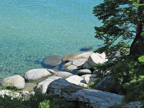
First Lily Pond on the right side of Blue Lakes Road

Date:          August 17, 2015
Time:          9:00 am
Place:          Choice of 3 locations in close proximity:
                    1st Lily Pond, 2nd Lily Pond or Lower Blue Lake
Meet:          First Lily Pond - parking on the side of the road
Amenities:   bathroom at Lower Blue Lake Campground and picnic area.  Also at the PCT Trail head parking at Tamarack Junction sign
Elevation:   above 8,000 feet
Closest gas:  Woodfords?  Markleville for sure.

General information:  This area is at the end of Blue Lakes Road (after you pass through Hope Valley on 88, you turn Left on Blue Lakes Road).

Directions from Reno etc:
Take 580 south to Minden, turn right on Hwy 88 to Woodfords, keep on 88 as you pass Sorensens and Hope Valley, turn Left on Blue Lakes Road, go to almost the end to meeting place.  Time and Mileage from Minden to Blue Lakes:  34.5 miles/55 min.

Directions from Lake Tahoe:
Go 50 to Myers, turn Left on 89, at Hope Valley turn Right on 88, then turn Left on Blue Lakes Road and go to the end.  Time and Mileage from Myers to Blue Lakes:  26 miles/43 min.

According to the map, the first thing you will see is a sign saying "Tamarack Junction" and PCT trailhead pointing to the left.  (there is a bathroom there)  Then the first lily pond is on your right.  The second lily pond is on your left.  Next the road ends at the Blue Lakes Campground where it turns to dirt road.  You cannot park in a campsite, but there are some dirt pull-offs - just beware of boulders and rocks.  The road gets real rough the farther you go - so it is not recommended unless you have high-clearance vehicles.

What to bring:

  • Bug Spray for the lily pond areas!!!!
  • Sunscreen, hat
  • Plenty of water - we are above 8,000 feet.
  • Lunch and drink
  • of course your art gear
  • light weight jacket - it is 10 degrees cooler than the lower elevations and it can be quite breezy at Blue Lakes
  • cell phones do not work here
Map:

Pictures:
Another view of First Lily Pond

2nd Lily Pond  on the left side of 88 - this one is private property
Lower Blue Lake from the camping/picnic area
Another view of Lower Blue Lakes from camping/picnic area
Links:  
http://www.carsonpass.com/lodging/blue_lakes_camping.html
http://recreation.pge.com/Campgrounds-and-RV-Parks/All/Lower-Blue-Lake-Campground/Overview

Saturday, August 1, 2015

August 10, 2015 (Monday) Bliss State Park Paint-Out


Date:          August 10, 2015 (Monday)
Time:          9:00 am
Place:          Bliss State Park, Lake Tahoe
Meet/Park/Paint:    Lester Beach Parking lot
Amenities:  Bathroom, beach, beautiful views, picnic areas, trails
Fee:          $10 entrance

Back by popular demand!  This time we will meet at Lester Beach Parking Lot.  It is a larger parking lot than Rubicon Point, and a little closer walk to the beach.


Map available by download:  go to this site:  http://www.parks.ca.gov/?page_id=505 and then click on "Brochure" and then go to page 7 (the map) and print page 7 - it will download as a PDF.

Directions:  Please use Google Maps to decide which is the fastest from your location.  It could be going Mt. Rose Hwy and going north along the lake through Tahoe City and then down to Bliss, or it could be Hwy 50 to South Lake and going past Emerald Bay for others.  Still others may find I-80 to Truckee and going to Tahoe City via 89 and then on down to Bliss is the fastest route.