Showing posts with label plein air paint-out. Show all posts

Tuesday, November 21, 2017

Two Upcoming Paint-Outs

TWO UPCOMING PAINT-OUTS

TUESDAY  November 28, 2017:   Silver Saddle Ranch   10:00

Place:          Silver Saddle Ranch, Carson City
Parking:       Parking area .6 miles down their gravel ranch road see above
Amenities:    bathroom, hiking trails, bird watching, picnic area, working cattle ranch, barns and caretaker house, hiking and horseriding trails
Meeting Place:   the parking area.  Painting areas in walking distance.
Directions:    
From Reno, take 580 south
Take exit 38 for Fairview Drive, keep in left lane
Turn Left at the light onto Fairview Drive
At the round-about, take 1st exit onto East 5th Street
Turn Right on Carson River Road
Follow Carson River Road for 1.4 miles to the entrance at a bend in the road.
Picture above shows their sign on Carson River Road
Follow their gravel ranch road .6 miles to the parking area near the hay barn and ranch buildings.

Links, pictures and trail maps:  
Friends of Silver Saddle Ranch  http://fossr.org/


What you can paint:
  • cattle (maybe - they do move around)
  • ranch and pasture vistas
  • view of Slide Mountain
  • some sagebrush and cottonwood trees
  • nearby Carson River if you choose to drive down the road
  • Ranch buildings


WEDNESDAY  December 6, 2017:  Oxbow Nature Center  10:00

Place:          Oxbow Nature Study Area, Reno
Parking:       Yes
Meeting Place:    Parking Lot
Amenities:    Restrooms (open?), Cafe
                     nearby

There are cottonwood trees, interesting vistas, the river, cattails, grasses, a small lake/pond.  There is plenty of parking and flat trails and boardwalks.  The home before you enter the park has some livestock that are fun to paint too.

Directions:  Take the Keystone Exit off of I-80 and turn south onto Keystone Ave.  Continue to W. Second Street and turn Right (West).  After several blocks Second Street bears left and becomes Dickerson Road.  There is no sign indicating but just go that way.  You travel through a semi industrial area and the road dead-ends into Oxbow Nature Study Area.

Links:
http://backyardtraveler.blogspot.com/2006/12/renos-oxbow-nature-study-area.html

Tuesday, January 10, 2017

January 16, 2017 (MONDAY) SAND HARBOR PAINT-OUT


Date:    January 16, 2017 (Monday)
Time:     10:00 am
Place:    Sand Harbor State Park, Incline
Meet:  Look for Carol Grigus at the Boat Launch Parking Emma and Look for the Easels
Fee:            about $10 per car if you don't have a year placquard
Amenities:    bathrooms?
Restrictions:  no dogs
There should be lots of snow so dress accordingly and drive safely!!
What to bring:
  • park entry fee money (about $10)
  • your lunch and beverage or purchase there
  • hat, sunscreen, sunglasses
  • bug spray (bee season)
  • your painting gear 
  • your beach and/or water recreation needs
  • cell phone
  • camera
  • folding chair?

Directions:

From Reno:  Take the Mt. Rose Hwy(431) to Incline.  Turn left at Country Club Drive (there is a sign that says "Sierra Nevada College" - that is the turn).  At Hwy 28 (the road that goes along the lake) turn left.  Go south on this road about 3 miles.  Sand Harbor is on your right.  The boat launch parking is the first turn.  The main entrance for people without boats is the next entrance.  

From South Lake Tahoe - take HWY 50 towards Carson City.  At the summit get in the right turning lane and turn right on Hwy 28.  Go about 10 miles towards Incline.  Sand Harbor will be on your left before you get to Incline Village.

t

Thursday, October 27, 2016

October 31, 2016 Oxbow Nature Area Paint-Out

This was winter or fall 
HOST:  Emma Auriemma-McKay
             I will be on this deck area.  From the 
             parking lot walk west on the trail closest              to river.

Date:           October, 2016 (Monday)
Time:           9:00 am
Place:          Oxbow Nature Study Area, Reno
Parking:       Yes
Meeting Place:    Parking Lot
Amenities:    Restrooms (open?), Cafe
                     nearby

At this time of year there are probably singing birds,leaf colors on the cottonwood trees, interesting vistas, the river, cattails, grasses, a small lake/pond.  There is plenty of parking and flat trails and boardwalks.  The home before you enter the park has some livestock that are fun to paint too.

Directions:  Take the Keystone Exit off of I-80 and turn south onto Keystone Ave.  Continue to W. Second Street and turn Right (West).  After several blocks Second Street bears left and becomes Dickerson Road.  There is no sign indicating but just go that way.  You travel through a semi industrial area and the road dead-ends into Oxbow Nature Study Area.
What to bring (same as always):·                  camera
·                  cell phone
·                  drinking water and snack or lunch
·                  painting gear
·                  carts work on boardwalks and paths
·                  hat, sunscreen, sunglasses
·                  art umbrella?
·                  check weather for appropriate layers of clothing
Links:
http://backyardtraveler.blogspot.com/2006/12/renos-oxbow-nature-study-area.html

Tuesday, February 23, 2016

February 29, 2016 Silver Saddle Ranch Paint-Out

Date:          February 29, 2016 (Monday)
Time:         10:00 am
Place:          Silver Saddle Ranch

I may not be able to attend, but I think the cattle might be there....

Parking:       Parking area .6 miles down their gravel ranch road see above
Amenities:    bathroom, hiking trails, bird watching, picnic area, working cattle ranch, barns and caretaker house, hiking and horseriding trails
Meeting Place:   the parking area.  Painting areas in walking distance.

Place to eat lunch in the shade of the backyard of one of the ranch houses - picnic tables for the public


Directions:    
From Reno, take 580 south
Take exit 38 for Fairview Drive, keep in left lane
Turn Left at the light onto Fairview Drive
At the round-about, take 1st exit onto East 5th Street
Turn Right on Carson River Road
Follow Carson River Road for 1.4 miles to the entrance at a bend in the road.


Follow their gravel ranch road .6 miles to the parking area near the hay barn and ranch buildings.

Links, pictures and trail maps:  
Friends of Silver Saddle Ranch  http://fossr.org/


Tuesday, February 16, 2016

February 22, 2016 (Monday) Lower Eagle Falls Paint-Out


Date:          February 22, 2016 (Monday)
Time:          10:00 am
Place:          Lower Eagle Falls at Emerald Bay

I will not be able to attend, but I am setting this location per a request of one of our painters.  She says the road is clear and there is not much snow if any.

Amenities:    Bathrooms at Eagle Falls and Emerald Bay turn-off, but it is unknown at this time if they are open
Meeting Place:      Eagle Falls free parking area outside of the fee parking lot.


Directions:
From Reno:  take 580 south to Carson City, at the end of the freeway take Fairview Exit and turn Right onto Fairview.  Turn Left at old 395 So Carson Street, turn Right on Highway 50.  Stay on 50 going through South Lake Tahoe for a total of 27 miles.  Turn Right on CA-89/Emerald Bay Road.  Go 8.5 miles.  Trailhead and parking is on your Left.

Sunday, February 7, 2016

Tuesday February 9, 2016 Oxbow Nature Study Area


Hi all,

This is late notice, and it is on a Tuesday for a change.  It is supposed to be warm, and I tried to pick a place that wouldn't be too muddy from snowmelt.

REMEMBER, THIS IS A TUESDAY!  Hope to see you!

Date:          February 9, 2016
Time:         10:00 am
Place:         Oxbow Nature Study Area
Amenities:  Bathrooms.  Cafe down the street

Directions:  Take the Keystone Exit off of I-80 and turn south onto Keystone Ave.  Continue to W. Second Street and turn Right (West).  After several blocks Second Street bears left and becomes Dickerson Road.  There is no sign indicating but just go that way.  You travel through a semi industrial area and the road dead-ends into Oxbow Nature Study Area.

Friday, November 6, 2015

November 16, 2015 (Monday) Rain Date: River Fork Ranch/Genoa Paint-Out

Due to snow or rain expected on November 9, I have scheduled the same painting location for the following Monday - November 16.

Date:          November 9, 2015 (Monday)
Time:          9:30?
Place:          River Fork Ranch - or - Genoa Trees
Parking:      There is a large parking lot - free - open daily year-round
Restrictions:  No dogs

Amenities:  I think there is a porta pottie at River Fork Ranch.  If not, you can drop by the Country Store in Genoa just down the street.

River Fork Ranch is located at 381 Genoa Lane, Minden, NV 89423 near the historic town of Genoa in the Carson Valley.

Directions from Carson City:  Drive south on 395 for 8.7 miles
Turn Right onto SR 206/Genoa Lane and continue for 2.4 miles
The preserve and parking area will be on your left and is well marked with a sign.


More info: River Fork Ranch: 
http://www.nature.org/ourinitiatives/regions/northamerica/unitedstates/nevada/placesweprotect/river-fork-ranch.xml
Visit nature.org/nevadaarthttp://nature.org/nevadaart

What is there:  hiking trails, wildlife viewing, interesting woven flood plain control, wetlands, Carson River


To get to the views of the river - walk around the deck of the Interpretive Center and you will see a trail head.  It follows the river going south and goes for 2 miles.  The pictures I took above and below were the closest distance from the Interpretive Center.  If it is not muddy from prior rain, these trails are good for pulling carts.

River Fork Ranch has 2 trails - one that goes along the Carson River with open vistas, and another one at the east side of the parking lot that goes through or near the cottonwood trees and another fork of river.

Genoa Trees:  on Genoa Lane (206)

Directions:  From Reno, take 395 south.  Either turn right at Jacks Valley Road and follow it out to Genoa (for a scenic route), or, continue on 395 and turn right on 206 (Genoa Lane).  The intersection of Jacks Valley Road and 206 is where the Genoa Country Store is.  http://www.yelp.com/biz/genoa-country-store-genoa

Your choice!  Both are in the same area about a mile or less apart.
big cottonwoods on the side of the road near the Country Store, Genoa on Genoa Lane

Friday, October 30, 2015

November 9, 2015 River Fork Ranch or Genoa Trees Paint-Out

Taken last winter - River Fork Ranch
This is a choice of two types of locations - open space or the old cottonwood trees around Genoa.

No host - I will not be able to attend.

Date:          November 9, 2015 (Monday)
Time:          9:30?
Place:          River Fork Ranch - or - Genoa Trees
Parking:      There is a large parking lot - free - open daily year-round
Restrictions:  No dogs

Amenities:  I think there is a porta pottie at River Fork Ranch.  If not, you can drop by the Country Store in Genoa just down the street.

River Fork Ranch is located at 381 Genoa Lane, Minden, NV 89423 near the historic town of Genoa in the Carson Valley.

Directions from Carson City:  Drive south on 395 for 8.7 miles
Turn Right onto SR 206/Genoa Lane and continue for 2.4 miles
The preserve and parking area will be on your left and is well marked with a sign.


More info: River Fork Ranch: 
http://www.nature.org/ourinitiatives/regions/northamerica/unitedstates/nevada/placesweprotect/river-fork-ranch.xml
Visit nature.org/nevadaarthttp://nature.org/nevadaart

What is there:  hiking trails, wildlife viewing, interesting woven flood plain control, wetlands, Carson River


To get to the views of the river - walk around the deck of the Interpretive Center and you will see a trail head.  It follows the river going south and goes for 2 miles.  The pictures I took above and below were the closest distance from the Interpretive Center.  If it is not muddy from prior rain, these trails are good for pulling carts.

River Fork Ranch has 2 trails - one that goes along the Carson River with open vistas, and another one at the east side of the parking lot that goes through or near the cottonwood trees and another fork of river.

Genoa Trees:  on Genoa Lane (206)

Directions:  From Reno, take 395 south.  Either turn right at Jacks Valley Road and follow it out to Genoa (for a scenic route), or, continue on 395 and turn right on 206 (Genoa Lane).  The intersection of Jacks Valley Road and 206 is where the Genoa Country Store is.  http://www.yelp.com/biz/genoa-country-store-genoa

Your choice!  Both are in the same area about a mile or less apart.
big cottonwoods on the side of the road near the Country Store, Genoa on Genoa Lane

Wednesday, October 28, 2015

November 2, 2015 Sky Tavern Paint-Out


Date:          November 2, 2015
Time:         9:30?  With time change - get there when you can
Place:          Sky Tavern Ski Area
Parking:      Free - we usually are along the fence where the aspen trees and trails are
Amenities:    If we see workers there, we might be able to use the bathrooms if the building is open

Directions:  From Reno - take Mount Rose Hwy 431 about 12 miles up the hill from the intersection of I-580.  Just past the old Tanenbaum area you will see a snow removal shed on the left and then a blue sign for Sky Tavern with a gate that should be open.  If you go past it by accident you can turn around at the Mountain Top Sports Rentals.  

Monday, October 19, 2015

October 26, 2015 (Monday) "Dayton Toll Road" Paint-Out

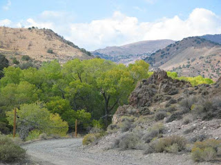
picture taken 10-19-15

This is a rural area with cottonwood trees in a canyon, rocky areas and lots of wild Nevada landscape

Date:          October 26, 2015 (Monday)
Time:          9:30 am
Place:          Dirt road named Dayton Toll Road
                    Maybe this is in the Dayton outskirts of town
Amenities:   None.  See below directions for nearby amenities
Parking:      Large dirt turn-out


Directions:
These directions are from Carson City 580/395:

Take the Highway 50 turn-off east towards Dayton
Go 5 to 6 miles
(Pit Stop - Look for a Shell Gas Station on your left.  This is your pit stop if you need it.  There is also a Pizza King restaurant in the strip mall next door.)
Turn Left on Nevada Hwy 341.  There are no businesses at this intersection
Go 2.7 miles
Turn right at 341 where road changes to 342 (see the mining building on your left)
Take another right (immediately) on Dayton Toll Road
Go about .5 miles on this dirt road.
After you cross a narrow bridge over a dry creek, there is a big open area to park.

The mining building on your left where you turn right on 341
we zipped right past this street the first time.  It is really immediate!
the parking area


Saturday, October 10, 2015

October 19, 2015 (Monday) Silver Saddle Ranch Paint-Out


The cottonwoods will start turning gold now...so it might be more colorful that these summer photos.
Sometimes there are cattle on the ranch.  Otherwise they might be across the street.
Just down the street a little further is Carson River Park - on the right side, a parking lot, picnic tables, trails along the river (which might be dry?) and cottonwoods there too.


Date:          October 19, 2015 (Monday)
Time:          9:00 or 9:30 am
Place:          Silver Saddle Ranch, Carson City
Parking:       Parking area .6 miles down their gravel ranch road see above
Amenities:    bathroom, hiking trails, bird watching, picnic area, working cattle ranch, barns and caretaker house, hiking and horseriding trails
Meeting Place:   the parking area.  Painting areas in walking distance.

Place to eat lunch in the shade of the backyard of one of the ranch houses - picnic tables for the public


Directions:    
From Reno, take 580 south
Take exit 38 for Fairview Drive, keep in left lane
Turn Left at the light onto Fairview Drive
At the round-about, take 1st exit onto East 5th Street
Turn Right on Carson River Road
Follow Carson River Road for 1.4 miles to the entrance at a bend in the road.
Picture above shows their sign on Carson River Road
Follow their gravel ranch road .6 miles to the parking area near the hay barn and ranch buildings.

Links, pictures and trail maps:  
Friends of Silver Saddle Ranch  http://fossr.org/


What to bring:
  • camera
  • painting gear
  • carts will work here - level ground
  • drinking water
  • hat, sunscreen, sunglasses, umbrella
  • lunch or snacks
  • folding chair if you wish
  • bug spray (where there are cattle....there are flies)
What you can paint:
  • cattle (maybe - they do move around)
  • ranch and pasture vistas
  • view of Slide Mountain
  • some sagebrush and cottonwood trees
  • nearby Carson River if you choose to drive down the road
  • Ranch buildings


Tuesday, September 22, 2015

October 12, 2015 (Monday) Twaddle Ranch Paint-Out


Date:          October 12, 2015 (Monday)
Time:          9:00 or 9:30 (depending on morning temps)
Place:          Twaddle Ranch, Washoe Valley
Amenities:   bathroom at little park next door, free parking

Directions:
From Incline:  
Take Mt Rose Hwy
Take 580 towards Carson City

Take Exit 50 for Bowers Mansion Road/Nev 429/Old US 395
Turn Right on Bowers Mansion Road/Alternate Old 395.  Go .4 of a mile
Turn Left on William Brendt.  Go .2mile
Left on to Susan Lee Circle Road.  The old ranch is next to Wilson Commons Park on your right.

Link to Map:

https://maps.google.com/maps?hq=http://maps.google.com/help/maps/directions/driving/mapleft.kml&f=d&dirflg=d


October 5, 2015 (Monday) Rock Park Paint-Out

Rock Park Paint-Out
Sorry No pictures
No host

Date:          October 5, 2015 (Monday)
Time:          9:00 or 9:30 (depending on morning temp)
Place:          Rock Park, Sparks
Address:     1515 S. Rock Blvd, Sparks
Amenities:   picnic, walking, rafting, bathrooms, Truckee River, free parking

Link:  :  http://www.cityofsparks.us/residents/parks-and-facilities/rock-park

September 28, 2015 (Monday) Hidden Valley Regional Park Paint-Out


Date:          September 28, 2015 (Monday)
Time:          9:00 am
Place:          Hidden Valley Regional Park, Reno
Address:     4740 Parkway Drive (off of Pembrook)
Parking:      Go to the upper parking lot closest to the trailheads
Amenities:  Picnic, hike, equestrian, bathrooms, dog park, views of city, free parking

Sorry, no photos.  This is a desert landscape with sage and rabbit brush.  Can be very pretty morning light with shadows.  Mountain views.  View of Truckee Meadows and city.

Directions:
From McCarran Blvd., turn east onto Pembroke Drive, drive past the Rosewood Lakes Golf Course and into the housing development. Several blocks into the houses, take a right on Parkway Drive and follow it to the park. There are several places to park depending on what you would like to see and do.
Links:


Wednesday, September 2, 2015

September 21, 2015 (Monday) Silver Lake (Kirkwood area) Paint-Out

photo is from the internet

Date:          September 21, 2015 (Monday)
Time:          9:30 am (I hope I get there then!)
Place:          Silver Lake, near Kirkwood
Meet:          Kit Carson Lodge (my first time there - seems like a logical place to meet)
Amenities:   said lodge - open until Oct. 1.  Meals, Kayak rentals, fishing, etc.
Painting spot:  My first time there - I want to paint the view above!  Wherever that is.
Info:          7,300 feet, 45 min. from South Lake Tahoe along hwy 88 just past Kirkwood Ski area
? Cell phone reception?  I don't know....

What to bring:

  • drinking water since high elevation
  • food or purchase
  • camera
  • art gear, tote
  • layers clothing (we are getting into fall)
  • good walking shoes or boots
Links:


Directions:  please refer to Google maps for directions from your location, mileage and time to allow.  

From Reno at 80/580:  Allow 1hr 47 min. - 87 miles total - Take 580/395 south to Minden, turn right on Hwy 88.  Stay on Hwy 88 for about 38 miles.  Turn on Kit Carson Road - lodge is .4 miles.
For Tahoe - take 89 from Myers up to hwy 88, go east on 88.

Address:  32161 Kit Carson Road, Kit Carson, CA  95644

Monday, August 31, 2015

September 14, 2015 (Monday) Tahoe Meadows Paint Out

north side of hwy
Tahoe Meadows is starting to change.  These photos were taken on 8-30-15.  There is a nice contrast of colors between the grass and willows...and the evergreens.
south side of hwy where the stair sign is
Date:          September 14, 2015
Time:          9:30 am (we are starting to meet a little later)
Meeting Place:     Near the stair sign above on the south side of Mt. Rose Hwy.  There are two sets of stairs but they are in view of each other.  I will be painting the meadow on this side.  Parking is on the side of the road, either side.

Painting locations:  You can paint either side of the hwy, or, if you prefer the parking area at the Tahoe Meadows trailhead - you can try that.  There is also a side of the road parking area just above the entrance to the Tahoe Meadows Trailhead parking lot.  You are higher up and can take in more view.

Amenities:         Bathrooms are at the parking lot for Tahoe Meadows Trailhead on the south side of the hwy a little more East than the above picture where the stairs are.  Bathrooms are also at the Mt. Rose Trail Head parking lot at the summit.

still some areas of green
creek runs through willows near one of the stairs

Monday, August 17, 2015

August 31, 2015 (Monday) Crystal Peak Park Verdi Paint-Out


Date:          August 31, 2015 (Monday)
Time:          9:00 am
Place:          Crystal Peak Park, Verdi
Amenities:   bathrooms, picnic tables, fishing, hiking
Downloadable PDF map of the park:  http://www.washoecounty.us/repository/files/28/Crystal%2520Peak%2520Park%2520Trails%2520Map%252017%2520x%252022


Directions:  Drive about 10 miles west of Reno on I80 and take the Verdi exit past Boomtown and Cabela's. At the stop, turn left on S. Verdi Road (there is a sign pointing to Crystal Peak Park). This road twists around, passing under I80, over the railroad tracks, and under I80 again. It turns into Crystal Park Road. Look for the park's upper parking lot on your left. Just before this lot, there is a sharp left turn that takes you to the lower lot by the picnic area, restrooms, and trailhead. There is a Crystal Peak Park sign here, but it is hard to see before you need to turn. (DIRECTIONS FROM THE INTERNET)

Links:
 Fly fishing at Crystal Peak Park: https://www.youtube.com/watch?v=-NuFeVnv_8Q