Monday, July 28, 2014

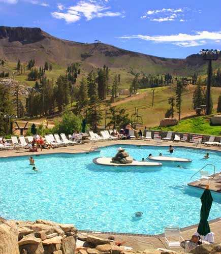
August 4, 2014 (Monday) Squaw Valley Paint-Out

Date:          August 4, 2014
Time:          9:00 am (if you want to paint in the village for 1-1/2 hr)
Tram:         10:30 am (if you want to ride to "High Camp" to paint from up there)
Place:          Squaw Valley
Meet:          In front of the Aerial Tram at 9:00 for a quick paint, and again in front of the Tram at 10:30 to ride up at 10:40.

This is a paint-out with many options!  Here they are:

  • paint "the Village" at the base
  • ride the Tram to High Camp to:
    • paint up there
    • swim up there
    • eat lunch at the restaurant up there

You can do anything you want to do

Aerial Tram Rates:
Adult (23-64)  $34
Senior (65-75) $22
Super Senior (76 plus) $8 (what a deal!)
See website for other age brackets

Tram/Swim Package:
Adult $38
Senior $30

Purchase your tickets early for discoun ratest!  Must purchase 24 hours in advance.  click on this link to purchase:  http://m.squaw.com/things-to-do/aerial-tram-rides

Directions:  click on this link:  http://squaw.com/trip-planning/getting-here

"A ride on the scenic Aerial Tram is a spectacular and leisurely ride 2,000 vertical feet to High Camp, elevation 8200 feet.  The Aerial Tram is one of Squaw Valley's most popular year-round attractions.  Once you reach the top, enjoy panoramic views of Lake Tahoe as well as access to numerous activities including a mountaintop pool, roller skating, hiking and dining.


Monday, July 21, 2014

July 28, 2014 (Monday) Watson Lake Paint-Out

Date:          July 28, 2014 (Monday)
Time:          9:00 am
Place:         Watson Lake
Meet:          At the turn-off from 267 at Brockway Summit at 9:00.  If you are late, just follow the directions:
Caravan:     Follow us 6 miles along Fiberboard Freeway (not a freeway) along the summit ridge, then we will turn left and go 1 mile to Watson Lake (total of 7 miles from Hwy 267
Amenities:    port-a-pottie, a lake, a small parking area
Parking:       Hopefully space for 5 cars - depends on if there are a lot of campers there

What to bring:
  • BUG SPRAY!  Last year there were mosquitos
  • painting gear that you are able to walk around the lake to where you want to paint.  
  • possibly an artists umbrella
  • hat, sunglasses, sunscreen
  • layered clothing - it can be cool up there it is 7,000 feet
  • hiking boots or good walking shoes
  • camera
  • drinking water, snack or lunch
  • cell phone - may not work up there
Directions:  
From South end of Reno to Brockway Summit:  About 30 miles/50 min:  Take Mt. Rose Hwy to Incline, turn Right on N. Lake Blvd. heading to Kings Beach, turn Right on 267 (No. Shore Rd) and go up to the top (Brockway Summit) and turn Left at the turn-out.  This is the entrance to Fiberboard Freeway.  Fiberboard Freeway is a paved logging road open to the public.  Take this road for about 6 miles (miles are marked on the pavement for bicyclists but last year we didn't see them).  At some point the road has changed name to Mount Watson Road.  Watch for a spur road to the left  with a big rock (see below photo) and sign that says "Watson Lake" (last year the sign was not there).  This is a short (less than one mile) road to the lake that ends in a parking area for picnic and hiking around this little lake.

From Northwest Reno to Brockway Summit:  About the same time and mileage, but go I-80 to Truckee, take 267 turn-off and head west toward Northstar.  Pass Northstar and continue up to Brockway Summit and look for the turn-off on the right.

From South Lake Tahoe to Brockway Summit:  Take Hwy 50 towards Carson City (north), Turn left at Spooner Summit onto Hwy 28.  Take 28 north to Kings Beach, turn right on Brockway Road/267.  Go to the summit.  Turn left into the turn-off area

For ALL DIRECTIONS:
From Brockway Summit to Watson Lake:  6.7 miles
There is no sign on 267 that says "Fiberboard Freeway".  Look for a turn-off very close to the summit.  Once you drive in there, a paved road will start and there is a little shack and a wooden sign with information on it.  In the winter, this area is where people snowmobile and park.


After going 6 miles on Fiberboard Freeway, look for the big rock with the paint on it to turn left to Watson Lake
Above is a picture I took last year.  The Fiberboard Freeway is the paved road going off to the right.  The big rock with the paint on it is where you turn left to go to Watson Lake.  I believe it is about a mile down this little road.  Last year the sign pointing to Watson Lake was missing.
This is where it ends - at the Watson Lake campground.
The .7 mile or so road that goes to Watson Lake dead-ends at the campground.  Park where ever you see space and are not in the camper's place.

Map:            http://www.tahoeloco.com/archives/2938  this link has a map that shows the paved road from 267 at Brockway Summit to Watson Lake.  If you click the zoom-in several times, you can see the names of the roads and even the trail names.

BONUS PAINTING SPOT:  While you are on the Fiberboard Freeway, enjoy the views especially to your left towards Lake Tahoe.  There are a few dirt turn-outs and little access short roads to meadows that are filled with wildflowers.  Last year we stopped at this spot to paint the Mule Ears:
Last year, Moxie enjoyed watching the fish in Watson Lake:

Wednesday, July 16, 2014

July 21, 2014 (Monday) Sand Harbor Paint-Out


Date:          July 21, 2014 (Monday)
Time:          9:00 am
Place:          Sand Harbor State Park
Meet:          In front of the Visitor Center
Fee:            $10
Amenities:    Bathrooms, Snack Shack, Bar with umbrella drinks!, soft icecream!
Roadwork on Mt. Rose Hwy - expect 10 min delay
What to bring:
  • camera
  • painting gear
  • $10 or more
  • cell phone
  • lunch & drink
  • hat/sunglasses/art umbrella/sunscreen
  • optional:  swimsuit, beach stuff and floaties!  It is that time of year!
Directions:
From Reno:  Take the Mt. Rose Hwy(431) to Incline.  Turn left at Country Club Drive (there is a sign that says "Sierra Nevada College" - that is the turn).  At Hwy 28 (the road that goes along the lake) turn left.  Go south on this road about 3 miles.  Sand Harbor is on your right.  The boat launch parking is the first turn.  The main entrance for people without boats is the next entrance.  

From South Lake Tahoe - take HWY 50 towards Carson City.  At the summit get in the left turning lane and turn left on Hwy 28.  Go about 10 miles towards Incline.  Sand Harbor will be on your left before you get to Incline Village.

ttp://parks.nv.gov/parks/sand-harbor/

Thursday, July 10, 2014

ANNOUNCEMENT OF RTPAP SHOWS!

Reno Tahoe Plein Air Painters will exhibit in upcoming shows!

RTPAP’s members, Carolyn and Emma have worked at and succeeded in securing venues for our group of artists to exhibit in!  They are:
  1. October 14 to November 21, 2015 at South Valleys Library Gallery, 15650A Wedge Parkway, Reno, 89511.  Show Chair:  Carolyn Jean Thompson
  2. 2015 to 2016 (Dates to be determined) City of Reno Gallery Shows.  This show will either be at the McKinley Arts & Culture Center or the Metro Gallery in City Hall (TBD).  The show will hang for 7 weeks.  Show Chair:  Emma Auriemma
  3. March through April, 2016 (Dates to be determined)  at Northwest Library, 2325 Robb Drive, Reno, 89523.  Show Chair:  Carolyn Jean Thompson

These exhibitions are open to all artists who have painted with us at least one time each calendar year.  Paintings you exhibit can be total plein air, started as a plein air and finished in the studio, or a studio painting you based on a plein air painting you did.  The scenes must be ones where we painted as a group or at least within 100 miles of Reno, Incline Village, or South Lake Tahoe.  (No paintings of Italy!)  You can be in any of these shows or all of them.  Initial sign-ups are open now until 4 months before each show begins.  (We need time to contact you in that 4-month window of time.)
Sign-up by emailing carolynjthompson@att.net with the following information:
  1. Your full name
  2. Your email address
  3. The city and state where you live
  4. Your phone number with area code
  5. Which show(s) you are interested in participating in
Looking forward to hearing from you!

Tuesday, July 8, 2014

July 14, 2014 (Monday) Donner Summit Rest Area (Eastbound I-80 Side) Paint-Out

this pond is about a 10 min. walk from the parking lot and quiet

Date:          July 14, 2014 (Monday)
Time:          9:00 am
Place:          Boreal/Donner Summit Rest Stop on the eastbound I-80 side
Amenities:        bathrooms and running water

Directions;  From central Reno, it is 41 miles (40 min.).  Take I-80 West.  Pass Truckee and continue up to the summit.  Take Exit 176 (Castle Peak/Boreal Ridge Road).  At the stop sign, turn Left and go under the freeway.  Turn Left again and get back on I-80 going East.  Take the immediate exit for the Rest Area on your right.  Park near the restrooms and we will meet there.

Yes, I realize this is a highway rest-stop....but, there is a BEAUTIFUL little trail loop there that is called "Glacier Meadow Loop Trail" - only about 1.5 mile in total.  As you walk this mostly level and easy trail, you travel away from the freeway noise and it gets quieter.  There is a quiet pond at the end of the loop trail (not the same one as right by the parking lot which is very pretty but noisy)  Here are some pictures of the trail if you take it in the direction of going off to the right side of the restrooms:


this is the pond by the parking lot that you walk behind and into the woods
much of the trail is like this, but some areas are rocky
the wildflowers are out
watch for signs or you might go on the Pacific Crest Trail instead!
there are granite areas carved by glaciers
next you go by a pretty little creek
next you get a glimpse of Castle Peak
now you get to the quiet pond - a great place!  this is also where the PCT intersections with the Glacier Loop Trail
now as the loop goes back to the parking lot, you go by a marshy meadow
now you travel back over the granite area to the parking lot

Tuesday, July 1, 2014

July 7, 2014 (Monday) Paint-Out Donner Camp Picnic Area or Prosser Creek - Truckee

Date:          July 7, 2014 (Monday)
Time:          9:00 am
Meet at:      Donner Camp Picnic Area, near Truckee, CA
Places to Paint:   Right there, or, up the road to the river crossing at Prosser Creek if you want to do a river
Parking:      At both areas
Amenities:    Pit toilets and picnic tables are at Donner Camp Picnic Area only

Detailed Descriptions and Directions to meeting place:

Donner Camp Picnic Area:  This is where we will meet.  There is a large paved parking lot.
Directions:  From Reno, take I-80 to Truckee.
The second exit after you go through the Bug Station is 267/89.  Take this exit.
At the light at the end of the exit, TURN RIGHT.
You are now on 89 going north.  Travel only 1.7 miles.
(You will go around 2 round-abouts - but just keep going straight).
A sign will indicate the picnic area is on your RIGHT.

Here are some pictures of the easy and level loop trail there:
You can stay here and paint - as you can see, there is a little creek and marsh area, an open vista, forest scenes, open meadows and view of the (dry) Prosser Lake in the distance.  There are picnic tables in the shade of pine trees and pit toilets.

The other painting spot is PROSSER CREEK.
Directions:  It is just farther up 89 about 1.5 miles and on your RIGHT.

It is a dirt pull-out parking for a trailhead that connects with the Commemorative Emigrant Trail.  Parking is free and the spur trail follows Prosser Creek.  There are views of Prosser Creek to paint, as well as a meadow that opens up and has a vista of the mountains.  The picture above of the vista is similar so I will only show a picture of Prosser Creek here:
What to bring:

  • camera
  • painting gear
  • artists umbrella (the altitude sun is intense)
  • hat, sunglasses, sunscreen
  • BUG SPRAY
  • Allergy medication - pine pollen!
  • Benedryl (it is a little early for yellow jackets - but if you are sensitive....)
  • Drinking water, snack/lunch
  • Cart or backpack or means to tote your gear
  • folding chair if you wish.  Remember, higher altitude
Links:


History of Donner Camp Picnic Area At this site on Alder Creek near Prosser Reservoir the George and Jacob Donner families were snowbound during the winter of 1846. The Donner Party had earlier decided to take a shortcut through the Wasatch Mountains in Utah, which Lansford Hastings had written about in his guidebook "Emigrants Guide to Oregon and California." The trail was rocky and portions were impassable for their wagons. The "Hasting's Cutoff" caused the Donner Party to become three weeks behind the rest of the wagon train they had originally started west with. When they finally reached Truckee Meadows (Reno), the party made the fatal mistake of resting for a week before going over the Sierra Nevada Mountains. The Donner families were forced to stay behind at what is now known as Donner Camps Day Use Area to repair a wagon axle while the others in the Donner Party went ahead. Both groups of emigrants were caught in early winter snows. The party that went ahead made it six miles farther to the site of the Donner Memorial State Historic Park before the snow stopped them.