Thursday, October 27, 2016

October 31, 2016 Oxbow Nature Area Paint-Out

This was winter or fall 
HOST:  Emma Auriemma-McKay
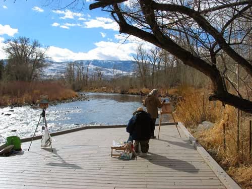
             I will be on this deck area.  From the 
             parking lot walk west on the trail closest              to river.

Date:           October, 2016 (Monday)
Time:           9:00 am
Place:          Oxbow Nature Study Area, Reno
Parking:       Yes
Meeting Place:    Parking Lot
Amenities:    Restrooms (open?), Cafe
                     nearby

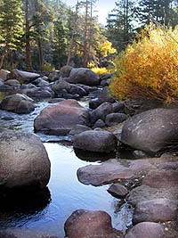
At this time of year there are probably singing birds,leaf colors on the cottonwood trees, interesting vistas, the river, cattails, grasses, a small lake/pond.  There is plenty of parking and flat trails and boardwalks.  The home before you enter the park has some livestock that are fun to paint too.

Directions:  Take the Keystone Exit off of I-80 and turn south onto Keystone Ave.  Continue to W. Second Street and turn Right (West).  After several blocks Second Street bears left and becomes Dickerson Road.  There is no sign indicating but just go that way.  You travel through a semi industrial area and the road dead-ends into Oxbow Nature Study Area.
What to bring (same as always):·                  camera
·                  cell phone
·                  drinking water and snack or lunch
·                  painting gear
·                  carts work on boardwalks and paths
·                  hat, sunscreen, sunglasses
·                  art umbrella?
·                  check weather for appropriate layers of clothing
Links:
http://backyardtraveler.blogspot.com/2006/12/renos-oxbow-nature-study-area.html

Monday, October 24, 2016

OCTOBER 24, 2016 (MONDAY) PAINT-OUT AT ARROWCREEK PARK


Date:          October 24, 2016 (Monday)
Weather and light it dicey today. Let's postpone today.

Sunday, October 23, 2016

OCTOBER 24, 2016 (Monday) PAINT-OUT AT ARROWCREEK PARK


Date:          October 24, 2016 (Monday)
Time:          9:00 am
Place:         ArrowCreek Park, ArrowCreek                      Parkway


Friday, October 14, 2016

October 18, 2013 (Tuesday) Paint-Out at Sky Tavern


Date:          October 18, 2013 (Tuesday)
                   Due to weather on Monday and also
                   depending on the fire situation
Time:          9:00 am
Place:         Sky Tavern on Mount Rose Hwy 431
Meeting Place:   Coming from Reno take first driveway into the work area and drive back towards pond
Mountain Top Sports Rentals at Bum's Gulch Road.  From there we can drive around into the Sky Tavern Ski Area which is obviously closed!  There is plenty of parking

 The picture is not showing the true colors.  But as you can see there are willows and creek-run-off areas, Aspen trees in yellow and evergreen hills.  There is a pond there now which should have wonderful reflections.

What to bring:

  • camera
  • painting gear
  • drinking water
  • lunch or snacks
  • carts will work in a lot of the areas
  • cell phone - not sure they will work well here - maybe
  • jacket or windbreaker
*In case there is wind we will continue back down toward Reno and go to Thomas Creek (off of Timberline Road)

Directions:  From Reno - take Mount Rose Hwy 431 about 12 miles up the hill from the intersection of I-580.  Just past the old Tanenbaum area you will see a snow removal shed on the left and then a blue sign for Sky Tavern where the gate is closed.  Just past that on the right is the Mountain Top Sports Rentals in above picture and turn right there.  That little road is called Bum's Gulch Road.  We will meet in this wide paved area.  I be painting by the pond.  continue a short way down and you will see my umbrella


Friday, October 7, 2016

October 11, 2016 (TUESDAY) Paint-Out Luther Pass Ranch/Hope Valley


Carson River near Sorensens
I may paint just across from Sorensen's or down at the river just before Luther Pass Junction on the right.  White Pathfinder

Here is a brief description of the locations to paint in that area:

1. Luther Pass Ranch:  About a mile from Pickett's Junction on Hwy 89 on the right-hand side.  This is an old ranch and the gate is still open.  Sorry, I do not have a photo of this area.

2. The area across Hwy 89 from Luther Pass Ranch is also a possibility.  This is still part of Hope Valley.

3. Carson River access:  There are many places along 88 to pull off and hike to the river for a beautiful view of just the river, aspens, willows, or the river and a view of Hope Valley and surrounding mountain peaks.  See map.  The areas indicated are in red from Sorensens to the beginning Blue Lakes Road.

Date:          October 11, 2016 (Tuesday)
Time:          9:00 am
Meet:          around the Pickett Junction area

   MORE INFO


A  Additional parking:  There is turn-off area on the left at Pickett Junction.  This is a large dirt staging area at the dirt road called Burnside Lake Road.  There is another off-highway turn-off when you first turn right on Highway 89 - parking headlight to taillight.

#1  Pull-out parking in dirt on the left before you get to Sorensen's.  Room for 3 or 4 small cars.  Short hike to Carson River.  Picture above is similar to this area.  Need hiking boots or boots with traction to walk down slope to River.  Link to Sorensens:  http://www.sorensensresort.com/

#2  Pull out parking in dirt on right just after you pass Sorensens.  Room for maybe 5 cars.  Short hike to Carson River banks.  Again, boots with traction recommended

#3  Restroom and parking lot at Pickett Junction.  Stay on 88 as you pass 89 turn-off at right.  Immediately after that there is a restroom and parking lot for about 6-7 cars.  Respect handicap parking spot please.  From here you can hike into meadow for a view, or, hike along a path to the river.

#4  Overlook Parking Area above Red Lake:  this is a few miles from Pickett Junction (my map is condensed).  Just before you get to Carson Pass, look for a sign saying something about Overlook of Red Lake (I don't remember the signage).  The paved parking area is on your LEFT.  Unless it is still has snow plow berms, this lot can hold a lot of cars - 15 or so.  The view is spectacular.

What to bring:

  • camera
  • cell phone (however service is next to none)
  • art gear
  • art umbrella, hat, sunglasses
  • food and drink
Services:  Sorensen's gift shop has snacks and maps, the restaurant is also open
Bathrooms:  Pickett's Junction and near the junction of 88 and Blue Lakes Road - on Blue Lakes Road.
Gas Station:  Markleeville and Woodfords

Directions from Reno:  Take 395 (580) South to Minden, turn right on Highway 88.  Approximately 1 hour 15 min. to Pickett's Junction from central Reno.


No comments:

Post a Comment


Saturday, October 1, 2016

OCTOBER 4, 2016 (TUESDAY) Thomas Creek Paint-Out

Aspen trees along the creek

Date:          OCTOBER 4, 2016 (TUESDAY)
Time:          9:00 am
Place:          Thomas Creek Trailhead located at the end of Timberline Road, Reno, NV.
Meet:          Try to meet at the dirt parking on the left after you cross the bridge.

Bathroom:   Pit toilet located beyond the bridge straight ahead - there is a paved parking area.
No drinking water available - bring your own

What to bring:

  • camera
  • painting gear
  • drinking water, lunch or snack
  • TP in case pit toilet is out
  • bug spray, sunscreen
  • carts will work OK here, but the dirt roads are bumpy and/or gravelly
  • cell phone - I believe they work here - we are close to a neighborhood

Directions:  From Reno, take 580/395 to Mount Rose Hwy exit.  Go up Mount Rose Hwy to Timberline Road.  Turn Right.  Go to the end.  It turns into a well-maintained dirt road that is only about .10 of a mile long.  

What you can paint near parking areas:  eastern vistas of Truckee Meadows, pine trees, aspen trees, and creek.  Thomas Creek Trail also goes east, following the creek near the bridge.  There are some nice aspen trees there too.  Basically - if you want to paint the view, park at the cement parking lot.  If you want to paint forests, creeks, aspens - park in the dirt parking area along the creek.  If you love hiking (and lugging your gear), the trails are wonderful - you can hike as far as you want.  The trail follows the creek toward Mount Rose....


Another option is to drive up Logan Creek Road.  There are a few turn-outs where you might like to paint.
About the trailhead at the end of the dirt parking along the creek:


People who use this trail:  hikers, dog-walkers, equestrians, mountain bike riders.

Important:  Do not set up easels on the foot trail.  This is a well-used trail.  Mountain bikes can whiz by without looking up.  Horses may be frightened by you and your easel and umbrella.  Try to be in an open area off the trail where the horses can see you but not be threatened.  I use this trail frequently and have never seen a rattle snake or mountain lion, but the trail signs say they do live there, so I feel obliged to note it here.

View from cement parking lot
The left fork where the dirt parking is along the creek

Bridge where the fork is 


A meadow between Logan Meadows Road and the creek - farther up  - parking for about 3 cars on Logan Meadows Road

Creek near the dirt parking area

No comments:

Post a Comment